Select NOAA-NWS Forecast Office Text Products

(Product availability varies with seasons, forecast office, and weather.)

Hazardous Weather Outlook for Omaha, NE

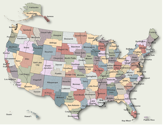
To Select Another NWS Office Click on Map or Choose from List

County Warning Area MAP
Select Forecast Office:   Select Product:  
195
FLUS43 KOAX 130944
HWOOAX

Hazardous Weather Outlook
National Weather Service Omaha/Valley NE
444 AM CDT Thu Mar 13 2025

IAZ043-055-056-069-079-080-090-091-NEZ011-012-015>018-030>034-
042>045-050>053-065>068-078-088>093-141200-
Monona-Harrison-Shelby-Pottawattamie-Mills-Montgomery-Fremont-
Page-Knox-Cedar-Thurston-Antelope-Pierce-Wayne-Boone-Madison-
Stanton-Cuming-Burt-Platte-Colfax-Dodge-Washington-Butler-
Saunders-Douglas-Sarpy-Seward-Lancaster-Cass-Otoe-Saline-
Jefferson-Gage-Johnson-Nemaha-Pawnee-Richardson-
444 AM CDT Thu Mar 13 2025

This Hazardous Weather Outlook is for portions of southwest
Iowa...west central Iowa...east central Nebraska...northeast
Nebraska and southeast Nebraska.

.DAY ONE...Today and Tonight

Extreme fire danger is forecast this afternoon into early evening
for northeast Nebraska for the combination of very warm
temperatures, low relative humidity, and windy conditions. A red
flag warning will be in effect for areas near and west of Highway
81.

.DAYS TWO THROUGH SEVEN...Friday through Wednesday

An intense weather system will move through the area Friday
into Saturday. South winds with gusts of 30 to 40 mph on Friday
will switch to northwest at 45 to 55 mph late Friday night into
Saturday. Travel may be difficult for light weight and high
profile vehicles.

There is a 10 to 30% chance for severe storms Friday afternoon
into evening, mainly in far eastern Nebraska and western Iowa. The
main threats are damaging winds and hail.

Accumulating snowfall up to a couple of inches appears most
probable in northeast Nebraska late Friday night into Saturday.
Regardless of snowfall amounts, any snow combined with the strong
winds will lead to very poor visibility with blowing snow and
potential travel impacts.

.SPOTTER INFORMATION STATEMENT...

Spotter activation will not be needed through tonight.

$$

Previous Hazardous Weather Outlooks may be found at
NWS Omaha, NE (OAX) Office Hazardous Weather Outlooks.
(Click 'Previous Version' there to view past versions successively.
Some may differ only in time posted.)

San Juan, PRHonolulu, HI Lake Charles, LA Pueblo, CO Corpus Christi, TX St. Louis, MO Reno, NV Raleigh, NC  Newport/Morehead City, NC Dodge City, KS Houston/Galveston, TX San Joaquin Valley/Hanford, CA Louisville, KY Fort Worth, TX Pittsburgh, PA Austin/San Antonio, TX Sacramento, CA Jackson, MS Phoenix, AZ Northern Indiana, IN Flagstaff, AZ Tallahassee, FL Springfield, MO Riverton, WY Blacksburg, VA Sioux Falls, SD El Paso Area, NM Columbia, SC Wilmington, NC Greenville-Spartanburg, SC Eureka, CA Midland/Odessa, TX Tucson, AZ Goodland, KS Huntsville, AL Amarillo, TX Norman, OK Lubbock, TX Marquette, MI Little Rock, AR Pendleton, OR Missoula, MT Binghamton, NY Boston, MA Green Bay, WI Billings, MT Baltimore/Washington San Diego, CA Tampa Bay, FL Morristown, TN Twin Cities, MN Brownsville, TX Portland, OR Des Moines, IA Memphis, TN Pocatello, ID San Angelo, TX Jacksonville, FL Aberdeen, SD Quad Cities, IA/IL Charleston, SC New Orleans/Baton Rouge, LA Peachtree City, GA Shreveport, LA Grand Rapids, MI Medford, OR Albany, NY Wichita, KS Gray/Portland, ME Spokane, WA Boise, ID Denver/Boulder, CO Great Falls, MT Caribou, ME Key West, FL Miami-South Florida, FL New York City/Upton, NY Melbourne, FL Hastings, NE Paducah, KY Glasgow, MT Bismarck, ND Charleston WV Omaha/Valley, NE Buffalo, NY Jackson, KY Kansas City/Pleasant Hill, MO Gaylord, MI Cheyenne, WY Grand Forks, ND Detroit/Pontiac, MI Central Illinois, IL Burlington, VT Salt Lake City, UT Topeka, KS Nashville, TN Milwaukee/Sullivan, WI Albuquerque, NM Las Vegas, NV Wakefield, VA La Crosse, WI Birmingham, AL Los Angeles/Oxnard, CA Chicago, IL Seattle, WA Rapid City, SD Indianapolis, IN Philadelphia/Mount Holly, PA Mobile/Pensacola State College, PA Cleveland, OH Elko, NV Wilmington, OH Grand Junction, CO North Platte, NE Tulsa, OK San Francisco/Monterey Bay Area, CA Duluth, MN Anchorage, AK Fairbanks, AK Juneau, AK Tiyan, GU

Products Courtesy of NOAA-NWS
NWS Information Parsing Script by Ken True at Saratoga Weather - WFO and Products Scripts by SE Lincoln Weather.
Mapping by Curly at Michiana Weather and by Tom at My Mishawaka Weather.